UgCS for Ground Penetrating Radar (GPR) surveys
DRONE FLIGHT PLANNING AND CONTROL SOFTWARE by SPH ENGINEERING
In most cases, GPR surveys are hard work and can be very dangerous for field personnel due to harsh topographic environments and weather conditions.
This is where drones come into play. They are lightweight (compared to a manned airplane or a helicopter), easily transportable by car and capable of flying autonomously at low altitudes with high precision. Such an approach assures delivery of accurate survey results, is also safer for personnel and more time-efficient.
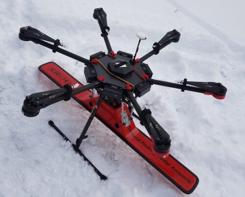
A GPR mounted on a drone enables to see through the surface of ground, ice, rocks, freshwater, and buildings or through structures at unsafe and hazardous environments without compromising the safety of staff, providing an additional solution for more efficient surveying.
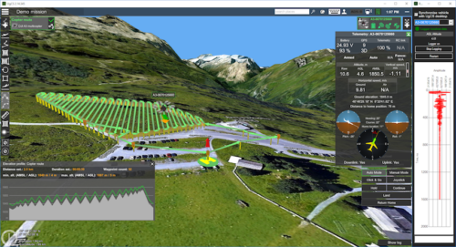
To enable full integration of the radar and drone SPH Engineering has developed a lightweight onboard data logger and the support of GPR for the ground control software for drones - UgCS. The result of the integration - the radar status and its current trace is displayed on the screen of UgCS (see Fig.1); Data logging is started automatically at take-off and finished upon landing.
✓ NEW] Automatic LiDAR toolset
✓ Terrain following
✓ Route import from KML or CSV files
✓ Photogrammetry tool
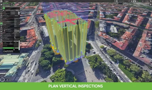
✓ Vertical scan tool
✓ Area Scan tool for non-camera sensors
✓ Corridor mapping, SAR patterns
✓ Import custom map and terrain elevation data
✓ Live geotagged video stream
✓ Work offline