-
 The YellowScan Explorer is the first LiDAR that can be mounted on a manned light aircraft or helicopter and switched to a UAV platform such as the DJI M300. This versatility allows the user to tackle a wide range of projects with the proven ease of use of YellowScan LiDAR UAV solutions.
 -
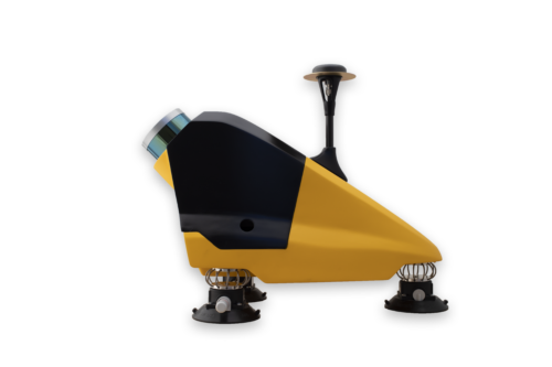
 The new YellowScan Mapper is our Livox-based UAV LiDAR system. The YellowScan Mapper UAV LiDAR system is equipped with a high-performance Livox Horizon laser scanner from Livox, a DJI-backed company. With a great point density, this LiDAR sensor allows our LiDAR system to fly easily at 70m AGL with a 120m swath. We recommend a balanced 10 m/s flight speed to benefit from the Mapper’s point density while being productive. For example, flying at 70m AGL, 10 m/s, with 20% sidelap, you will be able to map 10 ha in 3 minutes. The YellowScan Mapper is the right LiDAR tool to start with. Your data collection will be fast, accurate and cost-effective.
 -
 Designed to be easily swapped in minutes from vehicles to UAV. The YellowScan Fly&Drive is a versatile land vehicle-mounted or UAV-mounted mobile mapping system which combines high resolution laser scanning and precise positioning to collect geo-referenced point clouds for a wide range of applications.
 -
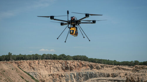 The YellowScan Voyager is a powerful solution for both manned and unmanned aircrafts. The laser scanner’s specs can be personalized to fit your different project and platform needs. With its laser scanner’s wide field of view, the entirety of the points are oriented towards the ground, meaning no loss of points. This also means 1.5 million points per second will be usable, which would not be the case with a 360° scanner.
 -
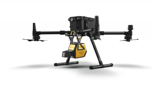
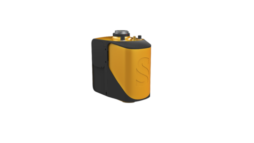
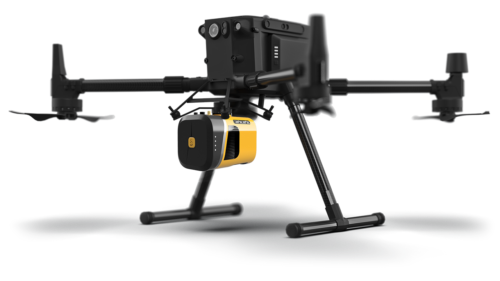 The new YellowScan Mapper+ can be mounted on a wide range of UAV platforms due to its low weight. The YellowScan Mapper+ integrates Livox AVIA laser scanner together with high performance GNSS-aided inertial navigation system into a lightweight, standalone and easy-to-use lidar system. Proven capabilities and stable results over a wide range of applications.
 -
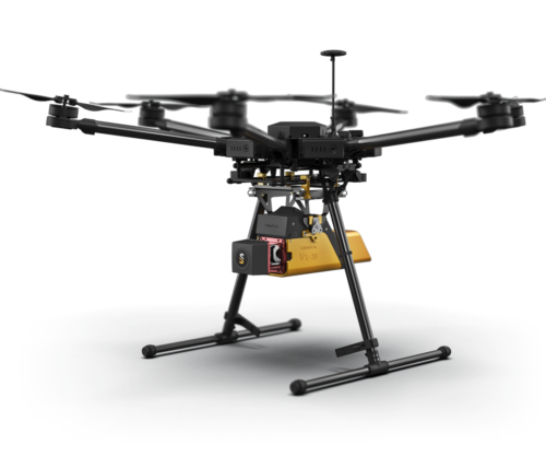 Having a longer range and more accurate system were the prerequisites of the Vx-series. YellowScan Vx20 is the most accurate fully integrated system from YellowScan’s product range. It can fly up to 100m while maintening accuracy throughout the point cloud. The Vx20 series is ideally suited for applications that requires sharp and accurate descriptions.
 -
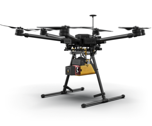 The long range & high precision UAV LiDAR solution. YellowScan Vx15 is the lighest system integrating the Riegl miniVUX. Having a longer range and more accurate system were the prerequisites of the Vx-series. Following YellowScan’s philosophy « Just press the Yellow Button », YellowScan designed an all-integrated, easy-to-use LiDAR system that includes the renowned Riegl laser scanner and Applanix UAV IMU APX-15. YellowScan Vx15 is an excellent solution for your high flight UAV projects with short-time data processing needs. It is ideally sized for all types of UAVs.
 -
 A numerical weather model calculates the current state of the atmosphere and the state of the future with the help of computers and on the basis of measured data, both locally measured and remotely sensed. Complex physical equations are used, which are calculated by high-performance computers with enormous power and processed into high-resolution weather forecasts.
 -
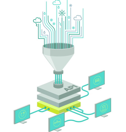 An API (Application Programming Interface) provides an interface for various programming languages that allows developers and programmers to integrate the data directly into their systems in the desired format in just a few steps. The Meteomatics weather API contains data on weather and climate. It provides access to over 25 weather models (e.g. GFS, ECMWF, DWD, MeteoFrance, UKMetoffice and many more) and more than 1800 weather parameters. Our interface is thus considered the gateway to the largest database of historical weather data, forecast data and climate data worldwide.
 -
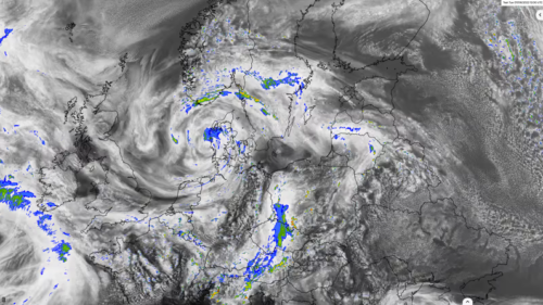
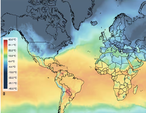 The weather events depicted can be past, present or forecast for the future. From a meteorological point of view, a weather map shows the current state of the atmosphere over a larger area. A weather map can provide information about certain weather parameters, such as temperature, wind speed, wind direction or precipitation. The weather observations or expected changes in the state are drawn in symbolic form or coloured contours.
 -
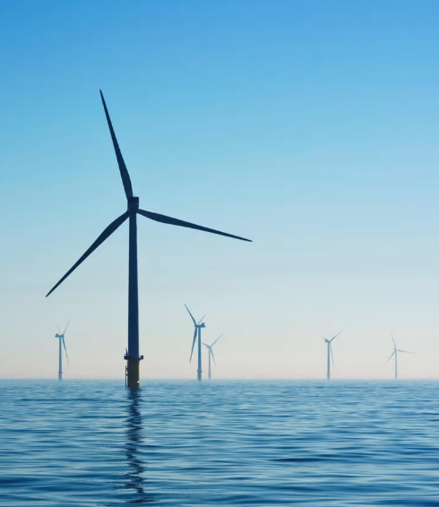 We offer detailed forecast systems and individual solutions, which we refine locally on the basis of high-resolution weather model data. Local conditions as well as live data from the respective power plants are included in our energy forecasts. This enables us to make precise energy forecasts for wind, solar and hydropower feed-in for different control areas and locations.
Contact us:
Contact us
-
786-2223099
-
16969 NW 67 Avenue, Suite 208, Hialeah, FL 33015
-
1601 SW 102nd Avenue Miami, FL 33165
Products
- Land surveying
- Weather systems
- GIS and remote sensing
©Copyrigth 2021 • Made with pasion by VoBo Marketing